Contractor goes above and beyond for NOAA
Sometimes contractors surprise you with how good a job they did. That was the case for the National Oceanic and Atmospheric Administration.
Best listening experience is on Chrome, Firefox or Safari. Subscribe to Federal Drive’s daily audio interviews on Apple Podcasts or PodcastOne.
Sometimes contractors surprise you with how good a job they did. That was the case for the National Oceanic and Atmospheric Administration. Its Office of Ocean Exploration and Research was so pleased with one contractor, the office chief wrote a formal letter of commendation. For the details, Federal Drive with Tom Temin turned to the chief of NOAA’s expedition and exploration division, Rachel Medley.
Interview transcript:
Tom Temin: Mrs. Medley, good to have you on.
Rachel Medley: Hi, thanks so much Tom. It’s great to be here.
Tom Temin: Give us a little background first of all about the exploration division — the expedition and exploration division — I guess you can’t explore without going on expedition. But what do you all do over there?
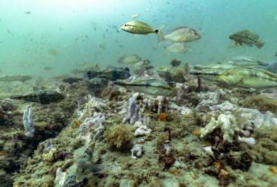
Rachel Medley: Sure. So NOAA’s Office of Ocean Exploration and Research, or OER, we’re the only federal program that’s really dedicated to exploring deep ocean, and in doing this we close a prominent gap in ocean exploration activities and understanding of the deep ocean. This helps make discoveries for science, the economy and provides a lot of cultural value and understanding — not to mention the inspiration that we all derive from learning about the deep ocean, an area that is pretty much completely unexplored. And our operating area, we are operating within the US exclusive economic zone and within our US boundary waters. But we also operate in the high seas across the globe and in international waters. As a public program at NOAA-OER we are we make all of our ocean data, exploration data completely both discoverable and accessible into National Archives, so anybody can access it, and we predominantly get a lot of scientists that do next generation sort of research and technology development. And so we really seek to encourage all of those different things swirling around deep ocean exploration, which we’re incredibly passionate about.
Tom Temin: I guess you could be called NASA looking down below the surface.
Rachel Medley: It’s so funny that you say that a lot of times we do partner with NASA, in that occasionally we’ve partnered with the other agency to test some of their different developments and things that they want to do in an extra terrestrial capacity, the deep ocean provides an amazing analog for testing, at least to the best of our abilities, what things might happen in deep space. So yeah, that’s that’s a great parallel draw for sure.
Tom Temin: Alright, and in connection with what we’re talking about, specifically, today, you had a manual or an instruction book on how to do this written up, tell us about what gave rise to the award, and we’ll get to that later on to Cherokee Nation.
Rachel Medley: Sure. I’m incredibly proud of the work that my team members on the expeditions and exploration division have been doing to create the NOAA-OER Deepwater Exploration Mapping Procedures Manual. I realize that’s a mouthful. It’s been in development since February and it’s now publicly available and accessible online both at the NOAA Central Library and the OER website. This manual is sort of the first its kind of at least that I’m aware of for deepwater mapping. And this is pretty focused on mapping activities. Certainly in the realm of exploration, we use a variety of different mechanisms and tools. But this manual itself was created by our mapping team who happen to be Cherokee Nation employees. So we’re very fortunate to have them on board. So the mapping team, they created this manual that represents years of accumulated knowledge about deepwater mapping and exploration best practices. And this knowledge base and these best practices were obtained through expeditions conducted on the NOAA ship Okeanos Explorer, which is our dedicated platform within OER.
Tom Temin: How big is this manual? And what is the range of procedures that it covers? Like how to anchor the ship versus how to deploy a camera 3000 feet deep or what?
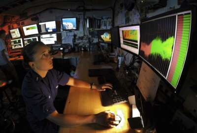
Rachel Medley: Mostly, it focuses actually on the acoustics of actually about acquiring mapping data. So it doesn’t go into how to operate the ships. It certainly talks about best practices if you’re standing watch and you’re acquiring mapping data. So we have a EM-304 multibeam sonar that we deploy on there. We also collect water column data. And then we also have an instrument that does some bond and profile data of the seafloor. So you can get a small slice of what the seafloor substrate looks like using sort of these mapping technologies. The manual really itself is just our best practices, how we are has conducted and collect data, how we archive it, how we process it. So these things sort of existed in separate workflows and sops throughout the office over the last 10 years, our last decade of operating on the Okeanos Explorer. But this past February, I charged the team with collating all of these things together, and refining our workflows and proccesses to be able to create this big holistic manual that we’re going to be using internally. But this manual describes sort of a pragmatic methods and standards that apply specifically to ship based exploratory ocean mapping. But we’re hoping that in the development and the refining of this, that both OER and any sort of external partners would be able to use this as a guide if they wanted to.
Tom Temin: How did it come to be that a contractor staff would prepare this instead of your own employees?
Rachel Medley: This is not unique to NOAA by any means, but within NOAA OER, we have a blended workforce that were composed of both federal employees, contractors and affiliates. Over the past few months, we’ve been fairly introspective and have seized upon sort of the opportunities to create this robust documentation and streamline our workflows and internal processes within the E&E division. So as I mentioned previously, our mapping personnel our mapping team, our CNSP employees, contracting employees, they were the natural sort of fit for scoping out this document, but they weren’t the sole kind of constructors of the document. There were many individuals across our office within OER that contributed to the construction, the review and the editing of this document. But I definitely felt like the work that these contractors did was really outstanding. They pulled together this really robust document in a timely manner that speaks to sort of the greater need for better documentation and understanding of how we map the deep water. And so I just wanted to acknowledge that really great effort, and I’m so pleased that it was so well received. They’re really a terrific team.
Tom Temin: So you gave a formal letter to Cherokee Nation — and that’s something that I guess doesn’t happen in normal contracting very often, does it?
Rachel Medley: Oh, well I don’t know. For me, I don’t know why you wouldn’t acknowledge good work, because these aren’t my direct employees, right. They work for Cherokee. I have lots of opportunities to recognize and acknowledge outstanding work within the federal system. There’s not too many mechanisms available to me to acknowledge great work with our contract team members. And so it just seemed to me like sending a letter of acknowledgement that this was great work and that it really contributed to the office just seemed like a no brainer.
Tom Temin: And as a practical matter, day by day, the contractors and the NOAA employees are pretty well integrated in terms of the working environment, right? I mean, they’re side by side.
Rachel Medley: Well, so these contractors are actually located in a different location and our mapping team is only made up of contracted. But as I mentioned before, it’s a blended workforce to be able to execute effectively execute our ocean exploration mission. In this case, I asked that we capitalize on a decade’s worth of standard operating procedures and workflows, streamline them into a single document for internal use, but also to share with the greater deep ocean mapping community. So again, they did an outstanding job at executing this task, couldn’t be more pleased with the quality of work and the breadth of knowledge that these contractors brought to this Procedures Manual.
Tom Temin: How does this manual fit into say some larger strategy of NOAA as a whole?
Rachel Medley: Thank you so much for asking that Tom. So the manual describes NOAA-OER’s principles and procedures as we’ve talked about for deepwater ocean exploration mapping, but it also supports the national strategy for mapping exploring and characterizing the United States exclusive economic zone, or the US EZZ. This specifically was developed by the Ocean Policy Committee at the White House of the Office of Science and Technology Policy. It was developed in coordination with NOAA and other federal agencies. The really great thing about the development of this national strategy is it calls for greater coordination of interagency mapping and exploratory activities within the US EZZ, developing new and emerging science and mapping technologies, and building public and private partnerships and completing mapping of the US deep water by the year 2030. So deepwater in the terms of this strategy is deeper than 40 meters of water depth.
Tom Temin: Rachel Medley is chief of the Expedition and Exploration Division at the National Oceanic and Atmospheric Administration. Thanks so much for joining me.
Rachel Medley: Yeah, my pleasure.
Copyright © 2024 Federal News Network. All rights reserved. This website is not intended for users located within the European Economic Area.


Tom Temin
Tom Temin is host of the Federal Drive and has been providing insight on federal technology and management issues for more than 30 years.
Follow @tteminWFED