NGA: Unclassified Arctic DEMs a treasure trove of data
To help U.S. agencies operating in the Arctic region, the National Geospatial Intelligence Agency has been releasing non-classified data to anyone who wants to use...
Whether you’re a commercial shipper looking for the fastest route, a climatologist concerned about rising waterlines or just someone who’s curious about the North Pole, the National Geospatial-Intelligence Agency has something to offer as part of an ongoing project to release unclassified data about the Arctic region.
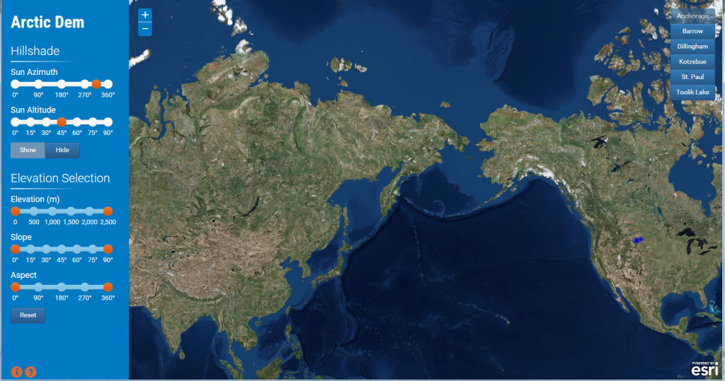
The NGA, with the help of Esri, a geographic information system company, and several American universities, is in the midst of releasing a variety of non-classified data as it works on creating digital elevation models (DEM) of Alaska and eventually all of the Arctic area.
These DEMs are compiled from images taken from commercial satellites and are used to show elevation at various spacing around the planet and also show tidal changes along the shoreline, Keith Dominic, chief of the Atlantic Maritime Division for NGA, told Federal Drive with Tom Temin.
“Since we’re building the digital elevation models, we have the experience to do it, so we’re using that and we’re also gaining knowledge of the Arctic while we’re doing this, so it’s enhancing our trade work as well as helping the public to see what changes are going on in the Arctic,” Dominic said. “This is the first time NGA is pushing digital models out to the public. They’re coming through DigitalGlobe contracts we have, and we’re working with the Polar Geospatial Center, also [The Ohio State University] and the University of Minnesota.”
Dominic explained that while NGA has its own satellites, the images from those satellites are not publicly available. However, the satellite images taken with DigitalGlobe satellites are unclassified, which is what NGA is using to build its models for public release.
“It’s a consortium all the way from [the Office of Science and Technology Policy], down to NGA, the National Science Foundation, the Polar Geospatial Center, and then the universities being part of it as well,” Dominic said.

That doesn’t mean NGA has stopped providing classified information to its military clients, Dominic said, but anything that’s unclassified NGA has been directed “to make it publicly available to anybody who wants it.”
The information will not only be available to the American public, but internationally as well. That’s because the Arctic is important to the five countries that circle it — the U.S., Canada, Russia, Greenland (Denmark) and Norway.
“You’re looking at the climate effects in the Arctic,” Dominic said. “It affects everyone the same way. We try to look at it as international, if we all work together to try and identify these areas, we pass all the information. All of our data is publicly available. In fact with the increased shipping lanes up there, NGA has a maritime product chart that allows you to sail safely through the Arctic, but also links to other sites.”
For example, if someone wants to see the route through Russian seas, a link would take you to Russian instructions on how to safely pass through.
Flooding, drinking water, search and rescue
Along with the tidal changes, the models hold a range of information.
“As more storms come in the tidal surges will be different,” Dominic said. “It’ll show you how much elevation there is from that shoreline, how quickly land increases, which as the water level goes up, could tell you how much the water level can go up before there’s flooding. [The models] can also tell you the drainage from when the ice melts, snow melts; how the water is feeding through the valleys, how people up in the Arctic are getting their drinking water from the streams that are coming down. Anything you can tell by elevation would be in these models.”

Right now five models are available — the spots President Barack Obama visited when he traveled to Alaska last year. Dominic said the plan is for NGA to finish the models for Alaska by March or April of this year, and all of the Arctic by spring of 2017.
NGA has also created a comprehensive map of the Arctic that includes boundaries, shipping routes, ports and airports, as well as search and rescue diagrams, Dominic said, which would show you “who would come help you in those areas.”
The models and maps are available on NGA’s site.
“If it’s in the Arctic and it’s unclassified, we will put it on our website and make it available,” Dominic said.
This data is possible through a cloud-hosting strategy that NGA is working on with Esri and the academic community.
While Esri operates the cloud storage, the universities involved are providing the algorithms to process the information as fast as possible.
“Our goal is to just get the data, if it’s unclassified post it, then academic and scientific researchers they can take the data and build whatever they want from it,” Dominic said. “This is the first time NGA is making digital elevation models available, but who knows what the future could bring.”
Read more Agency of the Month – NGA stories.
Copyright © 2024 Federal News Network. All rights reserved. This website is not intended for users located within the European Economic Area.


