Hubbard Radio Washington DC, LLC. All rights reserved. This website is not intended for users located within the European Economic Area.
On Air: Federal News Network
U.S. Geological Survey
-
![]()
By helping other nations set up systems to detect potential eruptions, the Volcano Disaster Assistance Program of the U.S. Geological Survey and USAID has saved tens of thousands of lives. Program leader John Pallister is a finalist in this year's Service to America Medals. He talks with Federal News Radio's Eric White on Federal Drive with Tom Temin.
July 01, 2016 -
![]()
David Hebert and Cori Bassett from the Federal Communicators Network, will talk about the organization, and the services it provides to communications professionals in the federal government. April 21, 2014
April 21, 2014 -
![]()
While the latest rounds of buyouts and early retirements span agencies as diverse as the Naval Sea Systems Command and the Interior Department's Bureau of Land Management, one thing many of them have in common is the targeted nature of the offers. In many instances, agencies are targeting offers to employees in specific job areas or agency locations.
February 25, 2014 -
![]()
Kevin Gallagher, the associate director for core science systems at USGS, said the agency is developing a new data management strategy that will help it meet the White House requirement to make federally-funded research data more easily accessible.
July 24, 2013 -
![]()
Fergal McGovern, Visible Thread\'s CEO, talks about which government agency websites do a good job of relating complex information in a clear way.
November 14, 2011 -
![]()
Jennifer Krstolic is a biogeographer for the U.S. Geological Survey.
October 07, 2011 -
![]()
The work by Dr. Paul Hsieh has led to a nomination for a Service to America Medal in the Science and Environment category.
May 10, 2011 -
![]()
Three days after the devastating earthquake in Japan, the U.S. Geological Survey updated the magnitude from 8.9 to 9.0, making the earthquake the fourth largest ever recorded.
March 16, 2011 -
![]()
Learn more about the USGS\'s efforts to prepare the city in the event of a megaflood
September 07, 2010 -
![]()
-
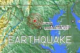
![]()
As a magnitude 3.6 quake struck the D.C. area just a few minutes past 5 a.m. this morning, the USGS stood ready within moments with answers. Geophysicist Jessica Sigala said it\'s all part of her really cool job in government.
July 16, 2010 -
![]()
NOAA\'s National Geodetic Survey - the official U.S. government source for determining precise latitude, longitude and elevation - is undergoing a modernization effort that takes into account advances in GPS and other technologies. chief geodesist at NOAA, Dr. Dru Smith, tells us where we are with that.
May 21, 2010 -
![]()
This week, host Jason Miller talks with USGS CIO Kevin Gallagher. Encore Presentation
October 14, 2009 -
![]()
Mike Blanpied received a text message at about 2:30 this morning. That is when the U.S. Geological Survey’s Earthquake hazards program associate coordinator learned of the ground shaking in Death Valley, California. Blanpied says that…
October 01, 2009