Hubbard Radio Washington DC, LLC. All rights reserved. This website is not intended for users located within the European Economic Area.
On Air: Federal News Network
How a seismic event lasting only a minute can necessitate years of repair
Millions and millions of people in the eastern part of the country felt an earthquake that originated in Virginia. The magnitude 5.8 quake occurred 10 years ago...
Best listening experience is on Chrome, Firefox or Safari. Subscribe to Federal Drive’s daily audio interviews on Apple Podcasts or PodcastOne.
It didn’t last long. But millions and millions of people in the eastern part of the country felt an earthquake that originated in Virginia. The magnitude 5.8 quake occurred 10 years ago today, and yet damage in some places is still under repair. For perspective, Federal Drive with Tom Temin turned to a research geophysicist at the U.S. Geological Survey, Thomas Pratt.
Interview transcript:
Tom Temin: Let’s start with a quick review of what actually happened on that August 23rd 10 years ago.
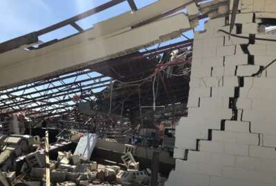
Thomas Pratt: We had a magnitude 5.8 earthquake in the Central Virginia seismic zone, and the central Virginia seismic zone has been a focus of ongoing earthquake activity for many, many years, couple 100 years. So it’s a well known seismic zone. It has a fair number of moderate sized earthquakes, magnitude 2, 3, 4. So this is the largest one we’ve had in quite a while, but it caused a fair amount of damage. It destroyed a couple of schools in the epicentral area and damaged a lot of other buildings. And it caused some damage in the DC area as well.
Tom Temin: Yes, I remember coming home from vacation, and we found that pictures had fallen off the wall, and a couple of things had fallen off shelves in the family room.
Thomas Pratt: So if that’s all that happens to you, and your should feel very lucky.
Tom Temin: Just needed to replace a piece of glass from the hardware store. And I guess the damage was widespread. I mean, the National Cathedral still has scaffolding up and that’s 10 years afterwards.
Thomas Pratt: Well, the Cathedral’s got a big problem there because it’s so expensive to repair all those things, and they don’t have huge amounts of funding. So yeah, the repairs are taking a while. The Washington Monument, of course, took a number of years, and then the elevator didn’t work so they had to go back and fix that. So yeah, it takes a while to repair some of these things.
Tom Temin: So was this event significant simply because of where it occurred, although you said that’s actually a common earthquake zone, or just the magnitude of it that had never been felt in reasonable history in that area?
Thomas Pratt: Well, this is the largest or most damaging earthquake we’ve had in over 100 years in the eastern US. So it’s a bit of a watershed earthquake in that sense, because it gave us a lot of information about how earthquakes behave in the eastern US, and how energy is transmitted in the eastern US and how energy is amplified in the eastern US. So it was an important earthquake from that perspective.
Tom Temin: So relative to what we know about, say, the San Andreas Fault and the famous dangers of the West Coast. This probably contributed to learnings about the East Coast or the eastern part of the United States.
Thomas Pratt: Yes, well, earthquakes in the East are of that size are so much less frequent that every one of them is a very large learning opportunity. In the West, you’re getting a lot of earthquakes this size, so you can study many of them. But it’s rare to have one in the east. And so it’s great to have one to study from a scientific perspective, obviously, it’s not great from a societal perspective. Sure.
Tom Temin: And the USGS, how do you collect data on these? What sorts of data sets come? Where does it come from? Do you have sensors throughout the country on the earth? And how does that all work?
Thomas Pratt: Well, there’s a lot of different data sets we collect the most fundamental is we have a seismic network throughout the eastern US and well throughout the whole world, actually. But throughout the eastern US, we have seismic stations that record the ground motion, and we can analyze what happened based on those. But then after the earthquake, we collected some dense magnetic data to try and look at the distribution of magnetic properties at depth. We collected very detailed topography using a system called LiDAR, which gets a very, very detailed look at the topography even through the trees. And we collected a number of seismic data sets by putting seismometers out to look at what’s happening with aftershocks, etc.
Tom Temin: And a ground station that measures Earth movement or earthquake parameters. What does it look like? Is it the size of a telephone booth the size of a tin can or what is it?
Thomas Pratt: Well, they range. The most Deluxe ones, which have a full suite of instruments on them are about the size of an ice chest. The more portable ones and the more easily deployed ones are about the size of an oversized beer can, you can put those in the ground and record quite quickly with those.
Tom Temin: So USGS has been in the Internet of Things business long before that term became popular.
Thomas Pratt: Yeah, well, we’ve had these seismic network since the 60s on a global basis.
Tom Temin: And do they have batteries to stay powered?
Thomas Pratt: Yeah, we have to have batteries, because most of them run off electrical power or solar panels. But when there’s an earthquake, the electrical power, you have to assume it’s going to go out. So we have batteries to take over at that point.
Tom Temin: And this LiDAR work and the work that you said, you can see the earth movement through trees – is there a satellite component to the after the fact measurement of what happened?
Thomas Pratt: Yes, we also have what’s called InSAR, which is a satellite based system where you look at multiple images from a satellite, and you can see the change in the ground elevation from before and after an earthquake. So those are used as well.
Tom Temin: We’re speaking with Thomas Pratt. He’s a research geophysicist at the US Geological Survey and oversees the eastern region of the United States. And there’s some new science that came from this that USGS is talking about, what is the new science as a result of that 10 year ago event?
Thomas Pratt: Well, it helped us understand ground motions a lot, in particular the distance that the ground motions carry in an earthquake, which is much larger than it is in the way West Coast. So it helped us with that quite a bit. But it also helped to look at the distribution of ground shaking, and in particular the effects of shallow sediments and other geologic features. And in fact, that’s probably why there was so much damage in Washington DC, as we have sediments underneath the city that amplified the ground shaking. And so we’ve been studying knows to try and understand the effect of those in future earthquakes.
Tom Temin: In other words, it’s built on a swamp largely, Washington, and that’s not great in an earthquake.
Thomas Pratt: Yeah, some of its man-made fill. And even in addition to manmade fill, there’s a very old sedimentary sequence there. It’s a couple 100 meters thick of sediments under parts of DC. And that amplifies the seismic shaking.
Tom Temin: And often I maybe wrongly think of the giant mountain ranges of the West as being a contributor here to the earthquake phenomena. What about the Appalachians in the Smokies? They look relatively small compared to the Rockies, but those are major mountains.
Thomas Pratt: Yeah, and they do influence earthquakes. There’s a seismic zone along the southern part of the Appalachians called the East Tennessee seismic zone, which is a very active seismic zone. But the Appalachians are very old mountains. And for example, the Central Virginia seismic zone, it’s unclear what the relationship between the old mountain belt is and the modern seismicity.
Tom Temin: And in examining this event and arriving at new science, did you also back roll on phenomena that happened maybe weeks or months before to learn what might be the indicators of the next big one here in the East.
Thomas Pratt: Whenever there’s an earthquake like this, we look for what’s called foreshocks. We look for smaller earthquakes that occurred beforehand, and we didn’t see any in the case of in Virginia, but sometimes you do. And sometimes you see earthquakes get triggered by other earthquakes. But this looks like a straight magnitude 5.8 earthquake, just out of the blue suddenly.
Tom Temin: And recently, in the past few weeks, there was a small one, I think, a magnitude two that happened in Maryland. A few people felt that. Any significance there?
Thomas Pratt: Those happen pretty frequently. There’s a number of them going on under Boston right now, for example. But yeah, you can expect magnitude two or three earthquakes pretty much throughout the eastern US. And we have no way to predict those. They just happen occasionally in a lot of areas. There was one a few months ago underneath Washington, DC, in fact.
Tom Temin: And how long have you been doing this type of work? And what got you interested in earthquakes in the first place?
Thomas Pratt: Well, I’ve been doing this – I’m as old as the hills – so I’ve been doing this for many, many years, decades. And I got into it sort of sideways. I actually went to school, and was expecting to go use seismic methods to look for oil and work for oil companies. But then I got diverted and got interested in earthquakes and ended up with the US Geological Survey studying earthquakes.
Tom Temin: And if there’s a major quake, do you go to where it happened? And have you felt some of the aftershocks? Or have you ever been on location during a big one?
Thomas Pratt: I’ve never been on location during a really big one. My colleagues and I do go to earthquakes and put in instruments to record aftershocks. The most recent one I was in was the magnitude 6.4 earthquake in Puerto Rico on January 2020. I went down there and installed some instruments. But that’s common for either myself or my colleagues to go and put instruments in after an earthquake.
Tom Temin: And just a quick follow up on some of the learnings from this big Eastern quake 10 years ago. You said one of those is the fact that the earth moves more than you probably previously thought it did. I guess the Cathedral could have ended up on the other side of Wisconsin Avenue maybe. But is there anything that city officials, building codes, people, constructors can learn from this?
Thomas Pratt: Well, I wouldn’t say the earth moved in the sense that that Cathedral is going to jump across the street. But the shaking is much stronger for much greater distances in the East, and that helps develop building codes. One of the main products in the US Geological Survey is the National Seismic Hazard Model, which is a map of the expected ground shaking. And that’s what is used primarily to develop building codes. And so when you build a building, you have to build it strong enough to withstand the expected ground shaking. So that’s where that feeds in and the earthquake provided a lot more information that’s useful for developing those maps.
Copyright © 2024 Federal News Network. All rights reserved. This website is not intended for users located within the European Economic Area.

Tom Temin
Tom Temin is host of the Federal Drive and has been providing insight on federal technology and management issues for more than 30 years.
Follow @tteminWFED
Related Stories
DIU teams up with civilian agencies to start humanitarian AI challenge
U.S. Geological Survey team earned SAMMIES nomination with Hawaii volcano coverage

Related Stories
-
DIU teams up with civilian agencies to start humanitarian AI challenge Artificial Intelligence