Hubbard Radio Washington DC, LLC. All rights reserved. This website is not intended for users located within the European Economic Area.
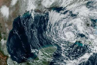
Weather scientists are constantly tinkering with models to get data from more sources. Now the National Oceanic and Atmospheric Administration has upgraded its ...
Best listening experience is on Chrome, Firefox or Safari. Subscribe to Federal Drive’s daily audio interviews on Apple Podcasts or PodcastOne.
When it comes to weather forecasting, everything depends on the model. Weather scientists are constantly tinkering with models, trying to get more data in them from more sources. Now the National Oceanic and Atmospheric Administration has upgraded its Global Forecast System model in a few ways. With the speeds and feeds, the Chief of the Modeling and Data Simulation branch at NOAA’s Environmental Modeling Center, Vijay Tallapragada, spoke to Federal Drive with Tom Temin.
Interview transcript:
Tom Temin: Dr. Tallapragada, good to have you on.
Dr. Vijay Tallapragada: Good morning, how are you doing?
Tom Temin: Okay, and we should point out that you were talking to me from halfway around the globe. And it sounds almost like you’re sitting right in my studio. Tell us the model that we’re talking about? Because I think NOAA has several weather models. Which one are we talking about here?
Dr. Vijay Tallapragada: Yeah, what we are talking about is the flagship American model. The colloquial name of the Global Forecast System. This is the mother of all models that weather service operates because it impacts almost every other modeling system that NOAA operates for various applications. So this is kind of a major upgrade that we do every two or three years. And the Global Forecast System, the GFS version 16, is the latest incarnation of that cycle of upgrades.
Tom Temin: And a model is a piece of software, correct? Tell us more about the size of it, what language it’s programmed in, and how it all exists.
Dr. Vijay Tallapragada: So these are the physical process in the atmospheric system coded into computer software, which is largely built upon Fortran 95. This is probably the only industry that still uses Fortran as a programming language. Although we added more object oriented programming into Fortran. And these cords are kind of 100,000-200,000 lines of codes. They run on powerful supercomputers, and they are integrated forward in time to predict what happens next. And in order to do that, you need to have initial conditions. That means what is at present happening in the world. And in order to do that, we collect all the data that we can, either from satellites, that remote sensing that send us billions of data points. We also have conventional data like the radio signs of balloons, the surface weather stations, the drop sounds from aircraft, and all aircraft data, and some commercial data. So they all are processed to create a model compatible initial conditions, or we call it analysis. Analysis is kind of a representation of the truth. And using that analysis as a starting point, the software that we wrote, the Global Forecast System software, forwards these data sets into time. And that is resulted in a forecast. And we call it loosely a forecast, but it is a guidance, the model provides guidance, it doesn’t give you a forecast. So the model provides products that can be interpreted to make a forecast. And the model is integrated out to 16 days, four times a day. So the model is updated every six hours predicting the weather across the globe 16 days out every time.
Tom Temin: Now of course, the weather is going to be different and the data is going to be different for Anchorage, Alaska versus New Delhi, India. So is the model deployed throughout the world? How does this divide the world in two segments so that you get a local idea?
Dr. Vijay Tallapragada: Now, this is a global model. What that means is the whole glob, the earth, as we see in the atmosphere, they are discretized into cubes or grid points, they are like pixels in a camera picture. So each pixel represents certain area and data collected over that pixel is used for that pixel to predict in the future. But the data through the surrounding regions and far apart also influences what happens locally. So you need to comprehensively understand the atmospheric flow across the globe that can influence not only the local conditions, but far away from where you live, or where you want to predict. And it’s not just the surface, it’s in the atmospheric depth. So we collect the data all the way up to 80 kilometers now with this upgrade. And that’s the major update that we can talk about. So we collect not only the surface data, but all the operate data that is contained in each pixel and processed and used for prediction.
Tom Temin: And before we get into the details of the upgrade, it’s fair to say that the more data, the better, in a given cube or pixel. But on the other hand, you’ve got to be able to run the model in time to have the forecast come out before the weather occurs.
Dr. Vijay Tallapragada: That’s true. We have to have all the data in place to predict all the significant weather events in time for forecasters to take advantage of, and then issue actual forecasts using not only the GFS, but several other sources that Weather Service provides.
Tom Temin: Now you have asked global wave model data called wave watch hill to this if I’m reading this correctly. So that brings in ocean surface information into the model. Tell us how it works.
Dr. Vijay Tallapragada: That’s correct. So this is the first time we we made a significant effort to combine the atmospheric forecasts with the weather forecasts. The way it operates is the waves, the ocean surface waves, are driven by atmospheric forcing, like the winds and temperature and radiation. In the past, the wave model takes that information offline after the GFS provides the data. Now with this upgrade, the waves are now constantly talking to the atmosphere, taking the more frequent information, more accurate information, and use that to predict the ocean forecasts of the surface waves out to 16 days. In the past, we were only doing it for 10 days. Now that we have combined both the atmosphere and wave models, it gives us an opportunity to extend the wave forecast also to 16 days, giving our marine forecast as an opportunity to look at two weeks out every single cycle.
Tom Temin: And hasn’t this been something that weather people and NOAA have been pursuing for quite a number of years, the idea of combining the ocean data and the atmosphere data, which seems like a logical thing to do, but it’s been a technically difficult thing to do.
Dr. Vijay Tallapragada: Right. And it’s not just the technical difficulty, it is the maturity of science. And our oceans are not as observed as the atmosphere. That provides a challenge to combine the ocean waves, ice, land, aerosols — into an atmospheric modeling system. We are moving towards the comprehensive earth system modeling approach to comprehensively evaluate and analyze the ecosystem in such a way that we can capture the influence of one on the other. Like oceans influence the weather, weather influences the waves, waves influence the sea ice forecast. All those are connected in the mother nature. For convenience, we tried to separate them. But now we have more advanced knowledge, our partners are working towards comprehensive earth system modeling approach. And we started working on a unified forecast system. So this is a next generation modeling system that NOAA is pursuing. And this allows us to conveniently put all these component models in the same framework and utilize all the information together to provide a couple of model forecasts. And we are making steps towards the direction, and one step is initially coupling to the ocean waves. And as we move into the future, we will also combine the actual ocean, deep ocean, as well as the surface ocean, along with the aerosols and land surface and chemistry and in all other system components.
Tom Temin: Sounds like you need a million more buoys here before this is all over. Is it fair to say that the wave data as well as all of the other data sources are collected as an international effort? It’s not just NOAA that measures the way it’s going.
Dr. Vijay Tallapragada: That’s correct. So NOAA has a major share because we have multiple satellites operating across the globe, both the polar orbiting and geostationary. And Europeans are the other major providers, along with Japan, some Asian countries. Everybody who has an observing capability, they provide the data through the global telecommunication systems that we receive, we share our data and other centers share their data to us. So it is a collective global effort towards understanding and analyzing the atmospheric system.
Tom Temin: What is the status of this combination of the wave data now? Is it done and you’re testing it or are you putting out the forecasts with it, or what’s going on?
Dr. Vijay Tallapragada: We still are not utilizing the wave data per se. We are still using the atmospheric forcing and spin of the waves. So it’s kind of halfway through. We are using data in an atmospheric model that drives the wave model. In the future, we will combine the wave data assimilation directly into our system. But for now, the atmospheric model still provides the forcing part of a model.
Tom Temin: So a little bit more Fortran yet to go here.
Dr. Vijay Tallapragada: Yep, more Fortran and more data.
Tom Temin: And can you still get the punch cards or those you don’t need anymore?
Dr. Vijay Tallapragada: Oh, glad you remembered that. I was probably the last person to see the punch cards in action back in 1995. But we are now in the cloud. and we don’t even need to see any media like the floppies or tapes. Everything is in ether. We don’t know where it is. But still we can get access to it and use them.
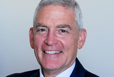
Tom Temin: Alright. Dr. Vijay Tallapragada is chief of the modeling and data simulation branch of the Environmental Modeling Center at the National Oceanic and Atmospheric Administration. Thanks so much for joining me.
Dr. Vijay Tallapragada: Thank you Tom, pleasure talking to you.
Copyright © 2024 Federal News Network. All rights reserved. This website is not intended for users located within the European Economic Area.

Tom Temin is host of the Federal Drive and has been providing insight on federal technology and management issues for more than 30 years.
Follow @tteminWFED