Hubbard Radio Washington DC, LLC. All rights reserved. This website is not intended for users located within the European Economic Area.
Eleanor Stokes, a senior scientist on the University Space Research Association's Earth from Space Institute in Columbia, Maryland, shared more details on the ...
Best listening experience is on Chrome, Firefox or Safari. Subscribe to Federal Drive’s daily audio interviews on Apple Podcasts or PodcastOne.
Studying nighttime images of the Earth taken from satellites could go a long way toward building policymakers understanding of disasters around the world and how to manage risks. That’s according to the UN’s latest Global Assessment Report on Disaster Risk Reduction. Eleanor Stokes is a contributing author to the report, who also helps lead the science team for a project called Black Marble. A joint effort by NASA and the University Space Research Association captures nighttime data around the globe every single night. Stokes is a senior scientist at USRA’s Earth from Space Institute in Columbia, Maryland, and she joined the Federal Drive with Tom Temin to share more.
Interview transcript:
Jared Serbu: Dr. Stokes, thanks for being here. Let’s, if you could start us off with a little bit of an introduction into what the Global Assessment Report is and tries to do for policymakers around the world. And then we’ll talk a little bit more about what Black Marble can do to help inform all those efforts.
Eleanor Stokes: Sure. The Global Assessment Report is a report on disaster risk reduction. It comes out every two years, and it’s exploring how systemic risk in the world has changed over time and what the current state of risk is. It’s put out by the UN. And it’s sort of similar to the IPCC for climate change. But this is focused more on disaster risk.
Jared Serbu: And unless I’m wrong, I think it actually deliberately excludes the effects of climate change, right, and tries to describe risk over and above what climate change might actually be doing in certain areas. Do I have that right?
Eleanor Stokes: Well, they’re sort of intermingled because it talks a lot about disasters and how disasters change because of climate change, their prevalence and their intensity. But it’s not just looking at how the physical disasters might change, but how the whole system might be affected. So the socioeconomic systems that are affected by that or the infrastructures, how we have changed the way we are exposed to those risks. So yeah, it’s not just about climate change, though, that is certainly one of the risks that it’s considering.
Jared Serbu: Got it, okay. So tell us a bit about Black Marble, the kinds of data you collect, and how that might inform efforts that are kind of described in that risk risk reduction report?
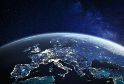
Eleanor Stokes: Sure. Black Marble is a project that NASA has funded. It’s a satellite data set, that is imaging the world at night since 2012, on a daily basis. And it’s really different from a lot of other satellite datasets, because at night, you can imagine you’ve probably seen these images that come up, usually before Hollywood movies of the world at night. The thing that really pops out is human settlements in that satellite data set. So what we’re able to see is things like electricity, infrastructure, roads, how populations might be moving or migrating, things like conflicts, electricity, reliability, and, and also how disaster affects all of those things. So it’s truly a human satellite, it’s focused on us as opposed to on the natural systems that support us and the other species that live on the planet. The reason Black Marble is so useful to this report is it starts to incorporate these physical models of of climate change and climate disasters with the social models of the impacts on humans and on cities. And so when you start to really do some data fusion between the satellite data we’ve had for years from the natural world with the human world, you really start to get a strong understanding of how risk is going to propagate to affect different parts of our economic and social system.
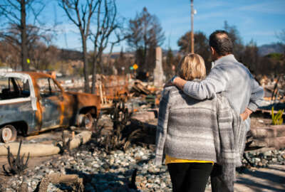
Jared Serbu: And I think you’re able to look at both long term and short term effects, right? I mean, things like long term migration patterns, and power outages. I think the report specifically talks about how Black Marble was used in the aftermath of the hurricanes in Puerto Rico.
Eleanor Stokes: That’s right. So yeah, I mean, one of the really cool things about satellite data that’s really well known is that we always shoot for a long-term record. So Black Marble has now been collecting data since 2012. It will continue to collect data for at least another decade. And so that’s like a long term record that we can rely on. But in addition, it’s collecting data on a daily basis. So we get to see short term changes, like how disasters might affect power outages. We’ve looked at New Orleans after different hurricanes. We’ve looked at the Texas outage that happened with the winter, Cyclone Fani. There’s a lot of impacts that are hard to understand the distribution of or study with just information from the power sector, or from producers of electricity because that data is often held within one district. So if you have a utility provider, they have a certain boundary that they care about. But the satellite data has no boundary, globally, across different utility providers’ domains and understand these outages at a very high resolution, spatial resolution. So neighborhood scale.
Jared Serbu: And now that we, let’s focus on the long term for a second here. Now that we do have a decade’s worth of data, can you give us some examples of the sorts of insights you’ve been able to generate over that longer period?
Eleanor Stokes: Sure, yeah, there’s a whole world of scientists that use this data. So I’m not the only one, we’re really the producers. And we try to get this out into the hands of scientists. But people have looked at how light pollution for example, and maybe more to the big data gaps that are out there, we have very little data about electricity reliability, like how often people have access to electricity. So this is one of the first chances we’re having to create a global dataset on electricity reliability, we’re working with the World Resources Institute, to do this to create this global data set that will be used by utilities all across the globe, who are trying to build out solar and other sorts of energy infrastructure for populations that need energy.
Jared Serbu: Yeah, and I would imagine that reliability data is especially helpful in some underdeveloped areas where maybe the local utility is not so great at keeping track of the data itself.
Eleanor Stokes: Exactly. And actually, the utility most utilities don’t have that data because they require smart meters. So you have, like a two-way feedback from the homes that lose the power to the utility central provider. So this is going to be helpful to them, have been able to invest in that kind of high tech technology.
Jared Serbu: And thinking back on the history of Black Marble, where these sorts of uses what USRA and NASA had in mind when the project was first launched, or are people just kind of constantly discovering new use cases for it?
Eleanor Stokes: No, it’s a great question. And the answer is absolutely not. This is the reason that black marble exists is really to image clouds. And for meteorological models. So weather drives that sensor and that satellite. So this is kind of a side benefit of having the sensor. But we’ve found, since having it in place, how useful it is for all of these other disciplines of science, and so now we’re trying to create the case to really have even more high temporal nighttime images to understand these short-term things like even traffic or migration patterns. Things that happen on a sub-daily basis, you can’t see. And right now, the sensor overpasses up around 1am. So we’re missing much of the human signal that that you could potentially see at like, say 9pm. So there’s definitely ways to improve our science around some of these questions. But so far, it hasn’t been the major priority that drives the launches.
Jared Serbu: Yeah. Is there now that all these uses have been discovered? Is there planning underway to launch something that’s actually purpose built together? To gather this imagery, maybe at a higher resolution than we could have done in 2012?
Eleanor Stokes: Yeah, you’re speaking to my dream. I think, I wouldn’t say plans but I would say there’s lots of discussions, and a lot of the land science community has put out reasons why we need this. And I think NASA is sort of weighing all their different priorities. And ESA, the European Space Agency, is also considering launching a sort of nighttime sensor, as is DLR, which is the German space agency. So right now we’re like the only one that has a publicly available nighttime sensor for use at this high resolution. But certainly other countries and other regions will catch up.
Copyright © 2024 Federal News Network. All rights reserved. This website is not intended for users located within the European Economic Area.

Tom Temin is host of the Federal Drive and has been providing insight on federal technology and management issues for more than 30 years.
Follow @tteminWFED