Hubbard Radio Washington DC, LLC. All rights reserved. This website is not intended for users located within the European Economic Area.
NOAA wants to upgrade its ability to analyze water resources, and it's asking for help from the information technology industry.
Best listening experience is on Chrome, Firefox or Safari. Subscribe to Federal Drive’s daily audio interviews on Apple Podcasts or PodcastOne.
The National Oceanic and Atmospheric Administration through the National Weather Service is trying to upgrade its ability to analyze water resources, and wants its forecasters to have better insight into flooding potential or water quality. Now, it’s asking for help from the information technology industry. To find out some of the details, the Federal Drive with Tom Temin spoke to the chief scientists for water prediction at NOAA, Fred Ogden, and scientist Fernando Salas.
Interview transcript:
Tom Temin: Mr. Salas, we’ll start with you. What is NOAA actually trying to do here?
Fernando Salas: As you just mentioned, we are trying to upgrade our water prediction system, so that we can provide our partners, the public emergency responders, with the best water predictions for any part of the country. So whether that’s the amount of water that’s flowing through the rivers and the potential inundation that may occur from extreme weather events, to droughts, and not having enough water for agriculture, or many different purposes, really just trying to build a modeling prediction system that can get the best forecasts out there, so that the decision makers can take the proper action to protect lives and property and more.
Tom Temin: And Mr. Ogden, I think this sounds like a pretty complicated question. Because if you’re predicting weather, you know, weather is up in the atmosphere, water is in rivers, it’s along the coasts, it’s in lakes, it’s in lowlands and wetlands. There’s so many different circumstances where water is and the ways that it can be affected. Is there any unifying principle that can apply here?
Fred Ogden: That’s a really good question, Tom. As you know, NOAA models the atmosphere, and it’s one atmosphere, maybe the physics of what’s happening, and a particular storm vary a little bit. And we also model the ocean, the ocean dynamics are pretty well behaved. But when it comes to hydrologic prediction, it’s not just water, it’s soil. It’s trees, it’s the weather. It’s how the land is used. It’s a very complicated problem. And the final outcome of that is, usually it means that one model isn’t going to work well, everywhere.
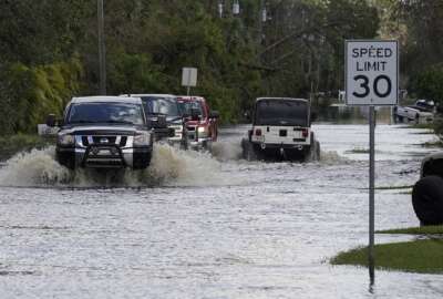
Tom Temin: Got it. And so what you envision, for example, would it have helped you think in mitigating some of what happened last week in Florida, where areas were badly flooded? It seems like the water is an after effect of the weather.
Fred Ogden: That’s true. There’s an aspect of this where above a certain amount, things just are way beyond our control and flooding is going to happen. The really challenging parts are where maybe there are thresholds in nature, or some little bit of rainfall in excess of some amount that you would normally plan for causes a major change. And that’s, that’s a really hard problem.
Tom Temin: All right. So let me ask you, Fernando, what’s the goal of this? It’s an RFI for I think that’s out for industry, you’re looking for software, or you’re looking for methodologies, what are you specifically trying to get?
Fernando Salas: Yeah, so over the past few months, we’ve been doing a lot of planning and performing a lot of market research has been contributing to some of the shared documents that we have released over the last few months here. Ultimately, we are looking for software technology acquisition, to help us build the framework under which we can evolve the national water model, which is our operational hydrologic prediction model that we currently have in operations, runs 24 hours a day, seven days a week, but we’re looking to improve upon that to tackle some of the things that Fred just mentioned. So building upon that, and then downstream from that also providing the detailed, accurate inundation predictions so that we can get that information over an entire watershed into the hands of decision makers. So it’s that whole modeling system, and how that informed decision support services that the weather service provides to emergency responders, partners and the public.
Tom Temin: And you are the director of the geospatial office here, the geo-intelligence division here. So there is a geographic component. I guess, as we mentioned earlier, that Fred had mentioned, it’s very location specific, what’s going on with water at some point on the earth?
Fernando Salas: Yeah, absolutely. A lot of what are modeled depends on is aggregating a lot of different types of geospatial information, whether that’s information describing what the soils look like, how deep they are, where the aquifers are, where the rivers are, where the snowpack lies where the built infrastructure is. We build bridges and levees and dams and reservoirs. And so being able to organize all that information in a consistent way, and feed that into our models so that we can then solve the equations. That’s a really important part of this.
Tom Temin: We’re speaking with Fernando Salas. He’s director of the geo- intelligence division, and Fred Ogden, chief scientist for water prediction, both at the National Oceanic and Atmospheric Administration. And I wanted to ask about what effect this acquisition might have on your computing infrastructure. NOAA has supercomputers, I imagine what you’re going to get is going to involve much more data, many more algorithms, a lot more processing, because that’s just the way these things run. What do you think is going to happen downstream for the infrastructure of NOAA?
Fernando Salas: Yeah, certainly, NOAA and the weather service continue to invest in upgrading the supercomputing infrastructure and related components. Certainly as like you said, as more data becomes available, we’re launching satellites, new satellites every day, micro-sensors, you know, the Internet of Things, will provide opportunities to assimilate more information into our models so that we can correct you know, any biases that exist. So, as we build out this technology, and do benchmark runs to see how much ultimate some compute power that we need, we’ll certainly work with, you know, weather service, and NOAA to continue refining those requirements, and ultimately, our funders, and look for opportunities to continue upgrading things as necessary.
Tom Temin: And is there a interagency aspect to this, I know you sort of encompass the National Weather Service, but I imagine the Navy and Army and Air Force weather operations and water operations, lots of agencies, I think, would care about this.
Fernando Salas: Both Fred and I work at the National Water Center in Tuscaloosa, Alabama, which is the instantiation of the integrated water resources science and services consortium, which includes FEMA, the Army Corps of Engineers, and the USGS. So we all work together to build water prediction capabilities for the country, and share information with each other so that we can do that in an efficient manner. We also recently I think, in April, or May, we announced a new cooperative Institute for research operations in hydrology, with the University of Alabama and 20 or so different partners. So certainly engaging deeply with the research community, to help accelerate some of that research to operations to inform this big IT acquisition that we’re looking to make in the next year or so.
Fred Ogden: The next gen framework was the requirements and design of the framework came from a set of interagency meetings involving US Geological Survey, Bureau of Reclamation, Army Corps of Engineers, and Department of Energy, you know, all the agencies have their own models, they tend to have their own modeling ecosystems. What the next gen framework does is it breaks down those barriers between models by using standards to unify how they run. And that is a major advance, I believe, for collaboration between federal water prediction agencies.
Tom Temin: And Fred, you are the chief scientist for water prediction. And I guess I’ve never heard that title. Suffice it to say that water predictors don’t use a Y shaped stick to figure out what’s going on. But is it your impression that water events are getting worse? I mean, you hear this in the popular press and so forth. But you know, we had floods of Galveston in 1906, or whatever it was, what’s going on with water? Or is it simply that people live near water in greater numbers than they used to?
Fred Ogden: The data clearly show that the climate is shifting. The occurrence of extreme storms is increasing. And it’s irrefutable. I mean, you can argue all day about what’s causing it. But the simple fact is that the climate is changing.
Tom Temin: So it is getting worse.
Fred Ogden: Yes.
Tom Temin: So this solicitation then, is pretty timely to get your infrastructure upgraded to be able to figure it out?
Fred Ogden: It absolutely is. In fact, one of the things that I’ll ask Fernando to talk about is the recalculation of rainfall frequency data that are used to design infrastructure.
Fernando Salas: Yeah. So with the support that we’re getting with a bipartisan infrastructure law, we also have the opportunity to perform a national analysis to help quantify and determine how rare different precipitation events or storm events over specified durations, how rare those are, and how those will be changing in a non-stationary climate. So that’s another workstream that we’ll be working on over the next few years, is to upgrade the NOAA Atlas 14 products to NOAA Atlas 15. And that will account for non-stationarity and the various climate model projections that are out there.
Tom Temin: And getting back to this RFI for industry help in this new model. What’s the timeline here?
Fernando Salas: So the timeline is about a period of five to six years. So looking for soliciting proposals sometime next year. And then the funding lasts about five years or so. So 2026, 2027 is the is the timeframe we’re targeting for delivery.
Tom Temin: And the delivery will be software?
Fernando Salas: Yes.
Eric White: Fernando Salas is a water scientist and Fred Ogden is the Chief Scientist for water prediction at the National Oceanic and Atmospheric Administration.
Copyright © 2024 Federal News Network. All rights reserved. This website is not intended for users located within the European Economic Area.

Tom Temin is host of the Federal Drive and has been providing insight on federal technology and management issues for more than 30 years.
Follow @tteminWFED